
When Fulcrum Books asked me if I’d like a review copy of a travel guide called The World Famous Alaska Highway, my first thought was what? drive… to Alaska? Even here from Seattle this seemed like a daunting prospect (though let it be said, I’m not one to drive for days on end, but I know many others who would leap at the opportunity).
My opinion, after flipping through these pages, has definitely changed. The author, Tricia Brown, has included a fantastic collection of photography, accommodation tips, restaurant suggestions, safety advice – everything you could possibly need, right down to where to stop and take the best photographs.
I’m now dying to see the wilds of northern British Columbia, the history of the Yukon, and explore some untamed wildness of Alaska – all within reach of a gas station, comfortable hotel, and good food. (I’m practical – what can you say?)
Here are some of the stops along the “World Famous Alaska Highway” that I found the most intriguing. Perhaps it will pique your interest and encourage you to make the trip!
The World Famous Alaska Highway
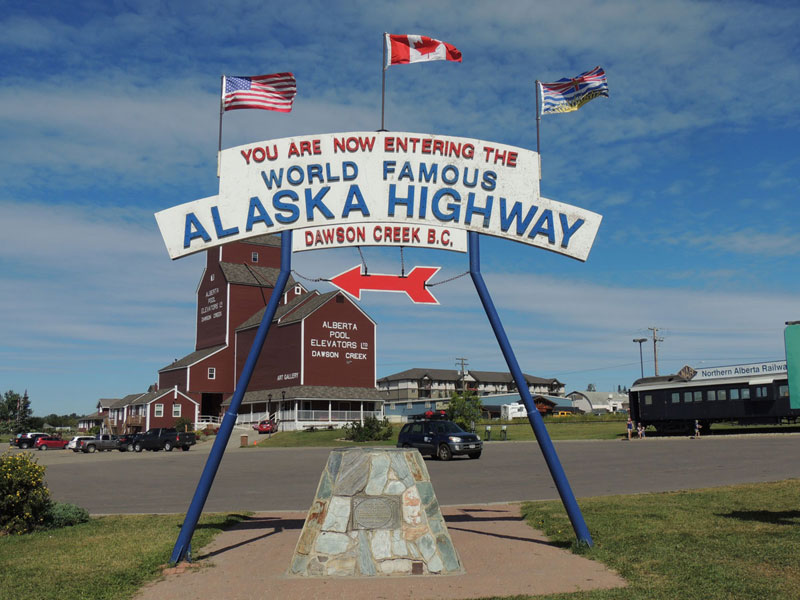
Your trip is basically incomplete without getting a photograph of this sign at the start of the highway in Dawson Creek. What is it with signs that include the worlds “world famous” that attract universal appeal? And at least you know you’re on the right path with the sign… it’s also worth nothing that Dawson Creek has an airport.
While in Dawson Creek you might want to check out the Alaska Highway House for some historical perspective on the road you’re about to drive.
Fort Nelson

You don’t have to worry about driving on what you might be stereotyping as a wild, untamed Alaskan or northern Canadian road – the Alaska Highway has all the modern amenities and is paved in nearly every section. The section south of Fort Nelson is the longest stretch of uninhabited road – 240 miles – but there are still plenty of stops along the way if you need anything.
As for Fort Nelson? It says it has the longest main street in the world: the Alaska Highway. Also some great parks nearby for recreation if you’re already ready for a break.
Part of the trip is getting there, and on this trip, getting there IS the trip. But how do you get to Dawson Creek? There are two main routes:
1) Head up from Vancouver and traverse British Columbia. It’s just under 700 miles from the American border to Dawson Creek.
2) Head up from Montana and traverse Alberta, crossing the border into British Columbia just before Dawson Creek. This is about 750 miles from the border.
Tetsa River Services – Cinnamon Rolls
75 miles west of Fort Nelson, you’ll bump into Tetsa River Services, who claim to have the best cinnamon rolls on the Alaska Highway on the continent in the world. Only one way to find out, right? ![]()
Muncho Lake

The emerald waters of Muncho Lake are your first signs that you’re about to enter a whole new world up here. From the highway, you get a fantastic view as the road runs right along.
While you are here, make sure to spare some time to stop at Liard River Hot Springs, the perfect place to relax and unwind those tense driving muscles. The hot springs are just about 30 minutes past the lake.
Watson Lake Signpost Forest
It’s so funny to find this in the guide, because I’ve used photos of this whacky place several times and never bothered to take five minutes and check out where it was from.
The story goes that a soldier from Eureka, Illinois posted a single sign here during the initial construction. (You can see it there in the photo). The signs seemed to multiply overnight, and now travelers from all over the world come to leave their own contribution. A quirky, must-see stop on your drive.
The Alaska Highway, also known as the “Alcan” (Alaska-Canda Highway), still starts at Dawson Creek, and still ends officially in Fairbanks. But it’s a shorter drive now because in recent years the road has been refurbished. The guidebook mentions a lot of historical quirks about the milemarkers that are still standing in some sections, which are now wrong. ![]()
Canyon Creek Bridge

Wondering what the original highway was like? It certainly wasn’t as smooth sailing as it is today – hairpin turns, curves, and bridges that probably would make you a wee bit uncomfortable were just part of the drive.
Canyon Creek Bridge still stands and is a great photo opportunity as well as a place to reflect on the original construction. (Er, no, you don’t have to drive over it.)
S.S. Klondike

Paddleboats were rampant like fireflies in the gold rush days. Over 250 of them were used as transportation before important transit links, like the highway you’ve been traveling on, were built. Most of them were left to rot under the Yukon’s tough winters, but the fine-looking S.S. Klondike in Whitehorse has survived and has been refurbished. It’s one of only two federal heritage sites in the province.
Welcome to Alaska

Yes, you’ve been driving all this time and still in Canada. Alaska may be in the name, but it truly is the “Alcan,” a road shared by both Alaska and Canada. Finally, at this point in your journey, Welcome to Alaska!. You’re in Poker Creek, 300-ish miles to Fairbanks, and well over a thousand miles back to where you started from. This sign is another popular photo stop. (It’s worth noting that the Yukon’s welcome sign facing the other direction is also very nice.)
At the gazebo by the parking area, you can sit in a bench that is half in Alaska, half in Canada. Also note the “official” border line – you can tell by its well manicured lawn – this line runs along the 141st meridian, which is how the border was drawn up.
Why was this highway built in the first place? Like many of North America’s engineering feats, it was completed during a time of war. In fact, the road was built in a huge rush – the American Army Corps of Engineers stormed in and started building, with the consent of the Canadians that they’d maintain their part afterwards. Both countries were afraid that Russian or Japanese troops could a bit too easily slip onto to the continent via some of the remote countryside.
Mukluk Land

I suppose one must pull off the road when one sees a gigantic mukluk (an Eskimo boot). The boot marks the entrance to Mukluk Land, near Tok, Alaska. It sounds cheesy, and it is, but you can learn a little bit more about the oil pipeline, the nothern lights, and if you have children with you, they can practice panning for gold – a skill you never know when you might need.
North Pole, Alaska

Not to cause undue confusion – no, you haven’t driven totally of course, though the panic-ensuing thought would be understandable – but there is a North Pole in Alaska, just outside of Fairbanks. The town residents actually named it the North Pole back in the 1940s, hoping to attract a toy manufacturer to boost the town economy. Instead, they got Santa Clause House, Candy Cane street lights, personalized ornament makers, and all-other-things-Christmas. Worth a stop for the kitsch factor alone, but great for souvenir shopping.
Fairbanks, Alaska

Your journey officially ends here in Fairbanks, Alaska’s second largest city. You could continue on to some of the unofficial routes, some of which are paved, many of which are not. Stretch your legs in Pioneer Park, or go on the popular Riverboat Discovery Tour. And celebrate your accomplishment – you’ve just traveled the World Famous Alaska Highway.
Photo Credits: Public Domain, Alan Vernon, Venue Photo, musubk, Bess Sadler, ukslim, sloan g., ash crowe, travis s., professor megan, systemf92
No Comments